Beginning Monday, March 22 through the end of the week, Norfolk Southern will replace 3 railroad crossings along several streets in the Wards Corner area from 7 a.m. – 7 p.m. The crossings were last replaced in 2011. The work requires full and directional closures with traffic detoured to signalized streets. Off-duty Norfolk Police hired by Norfolk Southern will assist with traffic control. The schedule, maps, and detour information are below. The city has established a 24-hour hotline to address construction concerns at 757-664-7220.
Monday, March 22
Granby Street southbound:
Traffic will be detoured to Admiral Taussig Boulevard to Little Creek Road and back to Granby Street. Alternate Route: Tidewater Drive
Granby Street crossing southbound (heading towards Downtown) closure map and detour: https://www.google.com/maps/d/edit?hl=en&mid=1zDaH1VulB9QaBxJxyq_O40SqynU&ll=36.91643049173739%2C-76.270625&z=18
Tuesday, March 23
Granby Street northbound (heading towards Ocean View):
Traffic will be detoured to Little Creek Road to Admiral Taussig Boulevard and back to Granby Street. Alternate Route: Tidewater Drive
Granby Street crossing northbound closure map and detour: https://www.google.com/maps/d/edit?hl=en&mid=1W4gu5zTSvQs6j-kE73BdhIiPu4Q&ll=36.91639599201156%2C-76.27058886441804&z=18
Wednesday, March 24
Little Creek Road:
Traffic will be detoured to Admiral Taussig Boulevard and Granby Street, respectively. Alternate Routes: Bayview Boulevard and Thole Street
Little Creek Road crossing closure map and detour: https://www.google.com/maps/d/edit?hl=en&mid=1bJOIFULJG6xPDAL97_f51WBc_iE&ll=36.9171789350947%2C-76.27065200000001&z=17
Thursday, March 25
Thole Street:
Traffic will be detoured to Little Creek Road via Granby Street and Tidewater Drive, respectively. Alternate Route: Granby Street and Willow Wood Drive
Thole Street crossing closure map and detour: https://www.google.com/maps/d/edit?hl=en&mid=1R7ZTmLPBqeg2pTdnc-bJzdsaF3Q&ll=36.91081466921791%2C-76.265037&z=15 Advertisements


 Posted by Wards Corner

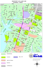 Norfolk city transportation engineer, Guzin Akan, has been working with the Talbot Park Civic League on measures to either slow or divert traffic on Newport Ave. The current proposed plan is not finalized, but Ms. Akan was nice enough to send along a copy of the proposed traffic calming measures that she presented to the Wards Corner Task Force on November 8, 2007.
